Awoke to rain pattering on the tent rain-fly this morning. After eating a leftover bagel for breakfast, washed down with water, I packed the wet tent, donned raingear, and set out for Northampton. As I was leaving the campground, the owner came out into the rain to wish me a good trip, and express her hope that the sun would emerge for me. Nice lady!
It was a 45 minute ride out of the hills and into Northampton. The roads were mostly deserted, as I rode along in the rain with my Vista light flashing away. As I approached one intersection, with stop signs on the side roads, a car approached from the left. He stopped at the stop sign, and I could see him look left, then right. We made eye contact. He started to pull forward into the intersection, then stopped. He looked at me again. As I was starting across the intersection, he moved forward again. He looked at me again, and slowed, then, finally, accelerated again and went through the intersection directly in front of me. I braked hard to avoid hitting him. I don't think the driver held any ill-intent towards me. I believe he was just confused. Didn't know what to make of the bicycle on the road. Was he supposed to wait for me, just like any other vehicle, or would I stop and wait for him, like the neighborhood kids probably do? I had done what I had learned. Always make eye contact. Be sure you've been seen. If I'm confronted with a similar situation again, with an obviously confused driver, I think I'll go one step farther and help make up his mind for him. I'll make it clear that I expect him to stop and wait. Lesson learned.
Soon, I was riding through the campus of beautiful Smith College, then into downtown Northampton. I was hoping to find some place to get breakfast in this college town, but nothing was open on this rainy Sunday morning, and I saw no one about to ask for suggestions.
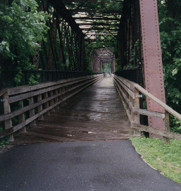 I crossed the Connecticut River on the Norwottock Rail Trail. This pedestrian/bike path utilizes an abandoned railroad bridge to cross the river. Once on the east side of the river, I turned north onto Route 47. This route had been recommended to me by several Massachusetts cyclists, back when I had been soliciting route advice on the internet. It was a good choice. Route 47 was dead flat, and passed by some beautiful farms highlighted by centuries-old farmhouses along the river. The wind was blowing hard out of the south-east, and I cruised easily along at 18 - 20 mph. At times, my speed and the wind would fall into sync. While the trees whipped back and forth in the wind, and the rain lashed down, I would be riding in a quiet pocket of calm air. Magical.
The best I could manage for breakfast was coffee and a couple of blueberry muffins at a farm-stand along Rt. 47. Soon after, 47 ended and I continued north on Route 63. While not quite as delightful as Route 47 had been, 63 continued to follow the river north, offering rolling hills to liven up my day. Passing through the town of Millers Falls was depressing. It looked as if every building in town was for sale. Dead. As I passed by Northfield Mountain Recreation Area, there was a mountain bike race in progress, which I watched for a while from the shoulder of the road.
Finally, I crossed back over the Connecticut River on Route 10, climbed the steep hill up to the intersection with Route 142, and wended my way north past dairy farms and small groups of homes. Passing through Vernon Vermont, I finally reached Brattleboro. After passing by the large lumber mill on the banks of the river, I picked the next left at random and climbed up into town. Thinking I was in the southern end of town, I was a bit surprised when I emerged onto Main Street in downtown Brattleboro. I knew that Fort Dummer State Park was located on the southern end of town, so I headed back south along Route 5. After stopping at the supermarket and doing some shopping, I got directions from someone in the parking lot, and headed for the park. With the weather still threatening rain, I rented a lean-to for the night. This was a wise choice. The lean-tos in Vermont state parks are huge, well maintained, and very pleasant. It's really nice to be able to keep my bicycle inside, under cover and always in sight. Shortly after I had showered and cooked dinner, the skies opened up and it poured for 45 minutes. Hopefully, that would be the end of the rain for a while!
The days statistics:
- 58.9 miles
- 4:38:17 riding time
- 12.7 mph average speed
Distance from home:
Day 1: Meriden CT to Westhampton MA
Day 3: Brattleboro VT to Ludlow VT