Friday, 6/19
AT Miles = 0 / 1111.6
Other Miles = 0 / 40.7
Total Miles = 0 / 1151.3
So, I slept in a soft bed with clean white sheets, in an air conditioned room last night. Nice. And I did very little walking today. I walked about a mile down the road to the grocery store to get just a couple of things to get me to Duncannon this weekend, and a pint of Ben & Jerry’s New York Super Fudge Chunk to have for a mid-afternoon snack. Then I walked over to the ATC Mid-Atlantic Regional Office to get some denatured alcohol for my stove.
I stashed the groceries back at the B&B, then walked over to the tavern for lunch. Papa Kiwi and a few other hikers were there and I joined them for lunch. They were heading back out so when they left I came back to the B&B and watched a movie streamed from NetFlix on my laptop, while enjoying my Ben & Jerry’s.
I did spend a couple of hours this morning processing and uploading photos. You can find them here:
http://picasaweb.google.com/affreeman1959/ATFrontRoyalVAToBoilingSpringsPA#
This afternoon has been bright and sunny and hot, so I hung my sleeping bag and the down jacket I use as a pillow every night, out on the line to bake in the sun. Those UV rays go a long way towards killing odors in my gear.
I will be heading back out tomorrow. Breakfast isn’t until 9:00AM here, which is terribly late, buit I only have 14 miles to go tomorrow so it should be fine. I will go to the post office to mail my bounce box ahead to Port Clinton when the PO opens at 8:00, then after breakfast I’ll head on out of town. The forecast for tomorrow calls for hot and humid weather with a 60% chance of thunderstorms. That should make hot work of walking across the Cumberland Valley out in the sun. About 8 miles north of here the trail crosses PA 11 on a foot bridge, and there is supposed to be a good diner just there, so I’ll probably stop there for lunch. Might as well take advantage of civilization while I can.
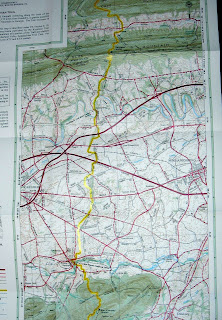
Here is what the trail map of the Cumberland Valley looks like. You can see that it looks more like a road map than a trail map. I expect to spend the day walking along the edges of farm fields:
And this is the elevation profile. I walked out of the hills on the left yesterday, and will walk across the dead flat Cumberland Valley tomorrow until I reach the hills over on the right tomorrow afternoon:

Some musings on being half way:
It was really exciting as I got closer and closer to Harpers Ferry, as a goal I had been working towards for nearly three months was within reach. Then I got there, enjoyed the feeling of accomplishment, and spent four more days getting to the actual half way point. That was kind of anti-climactic. And now, having reached the half way point, the full weight of the realization that I am only half way has descended upon me. I find myself contemplating the second half as a huge chunk of work ahead of me, and it’s intimidating. This is only temporary, I know. I just have to go through the process of adjusting my thinking and start picking out intermediate goals. And that should be easy as the states go by pretty fast from here up to northern New England. Pennsylvania, New Jersey, where a friend has already offered me a meal and a warm bed for the night, New York, then Connecticut, where I have family and a lot of hiking friends. Then comes Massachusetts, my home state, and then I’ll be in Vermont and hiking through the chunk of trail I have helped maintain for many years. Then will come New Hampshire and the mighty Whites, and finally the amazing wilderness of Maine. So much to look forward to.
And now, I am going to get ready to head back over to the tavern for another good meal, maybe accompanied by a very cold martini this time. Then I’ll come back here and relax while watching another NetFlix movie tonight. Might as well enjoy life while I can, as I expect to be soaking wet and maybe dodging lightning sometime tomorrow.